Gold Maps - How to Use Geological Maps and Systems to Target Gold in WA
The key takeaway from using Geological Maps is how to use them as "Gold Maps" to target gold in WA. i.e. To show the location and types of Geology where gold in likely to be found in WA. (Or anywhere in the world for that matter!)
Here are 4 basic criteria you use to find gold in an area More detailed in the "Where to Find Gold In WA." pages but broadly they are;
1. By Association
- Understand Rock Types that Gold occurs, eg Quartz, Ironstone.
- Look at Local Deposits and rock types.
- 1:250000 and 1:10000 Map Explanatory Notes.
Mineral or gold deposits in the local area tells you:
- The types of rocks to look for, and
- The geological structure it occurs in the Geological Map area.
Regolith (The rocks and soil between the bedrock and Surface) - Sediments Over Archean Rocks (Archean and Proterozoic Rock Types are the key Geological Age periods of formation of Primary Gold.) also host secondary gold formations
2. By Proximity
- Where gold has been found before.
- Old Gold Mines and Mining areas.
- Scraping detecting and dryblowing areas.
- Abandoned Mines.
3. Analysis of Geological Structure
- Use Geological Maps (Tengraph Web or GeoMap) as gold maps,
- Sills, Dykes, faults, contact zones, quartz veins
- Primary Archean rocks
- Secondary gold deposit types such as Laterite, Salt lakes, calcretes. Can be formed after erosion and chemical deposition in situ on top of or downhill, downslope or downstream from Primary Deposits.
- Hidden paleo channels. Ancient stream beds or waterways that have been covered by sediments.
4. Soil Sampling and testing to find Hidden Deposits.
- Historical soil sampling and drilling is available from WAMEX (WA Mines Exploration data can be shown and interrogated on Geoviewer, Tengraph Web and GeoMap)
- Minedex shows where minerals occurrences, mines, types of mines, drill holes, outcrops are. They can be viewed on Geoviewer, Tengraph Web and GeoMap)
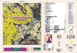
The geologic map patterns in an area enable you to create your own understanding of gold maps i.e. where gold is likely to occur in the locality where you are prospecting.
Explanatory Notes - Tell Y0u Where the Gold is Found
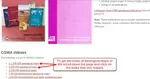
In the page on Geological Maps Online and how to get them there is also a link to "Explanatory Notes for 1:100000 or 1:250000 maps" these notes actually tell you in the Economic Geology Section what types of Geology minerals occur in the area of the Map.
That is Mighty Helpful!
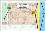
Geology and Gold in Tengraph Web and Using GeoMap as Gold Maps
Geology and gold locations can be identified on the freely downloadable PDF Geology maps described in the "Free Geological Maps" page or:
- in Tengraph Web which is an online program or,
- GeoMap which is an offline program that you use in the field.
It can also be used to identify the gold mines and occurrences and thus are gold maps as well as identifying the geology where gold occurs in an area.
How to use Tengraph web and GeoMap is more fully described in out training site www.geomap-training-wa.com which also has a series of Free training on the prospecting rules in WA and How to Locate Gold
The Free training Course conists of the following Elements:
1.0 The 4 Methods to Target Gold in WA
2.0 Rules and Laws for Gold Prospecting In West Australia
3.0 How to Access and Login to Tengraph WEB
4.0 An Overview of GeoMap
Historical Gold Mines on GeoMap

Geoviewer Can Be Used to Create Gold Maps

Geoviewer is an online program provided by the Department of Mines (DMIRS) and you can create gold maps using selected Geology Maps and information about gold mines taken from Minedex as in the graphic.
We will provide more information and training about Geoviewer shortly but information is available on the DMIRS Website at GeoViewer
Gold Maps Using Goldtracker To Locate Gold in WA
There are programs and apps that analyse all the technical data that you need to know to target a specific location to find gold in WA.
Goldtracker analyses the potential of gold deposits for every graticular block in WA. A graticular block is 1 minute by 1 minute of latitude and longitude.
It provides a colour coded and numerical score of the potential to find gold in that graticular block
There are approximately 1.09 million (1,090,080) graticular blocks in WA BUT less than 1% of the area of WA has the potential to produce Gold nuggets.
Goldtracker analyses and calculates a score based on a complex algorithm using:
- Geological Structure and Gold Deposit types (13 Types).
- Lithology and Chemical elements within each graticule e.g. Au, As, Se Fe, Mo, Ag, Bi (Above background).
- Economic Geology.
- Alluvial occurrences, workings, Historical Data,.
- Technical evaluation of likelihood of occurrences by Dr Watling and Ray Hammond.
There are 19000 graticular blocks that have a score of 80 or above in Western Australia.
A Score of 80 is considered to be of good potential for gold deposits in any block.
Goldtracker is available as an app here at Goldtracker App - Shows you Where the Gold Is in WA!
 GoldTracker Gold Potential Scores by Graticular Blocks
There are many ways to create your own gold maps to search for gold and with them you can laser focus on the areas of WA that you want to prospect for gold.
You might like these
Geology Maps Online Free
Geology Maps online - how and where to get them for free for WA
Different Types of Geological Maps
Different Types of Geological Maps can be used to see where gold has been found and the geology anywhere in WA
Geological Maps - Explained and How to Find Gold Using Free Maps
Geological Maps - Essential to find gold in WA - where you can get get free geological gold maps for WA
Return to Geological Maps Page from Gold Maps page
This Website Changes Over Time
So please bookmark us and come back regularly.
OR.. sign up for our egold newsletter to keep up to date with trends and knowledge about gold prospecting!
In Aussie Dollars
![[Most Recent Gold Price Quotes in Australian $]](https://www.kitconet.com/charts/metals/gold/t24_au_en_auoz_2.gif)
In US Dollars
![[Most Recent Gold Price Quotes in US $]](https://www.kitconet.com/charts/metals/gold/t24_au_en_usoz_2.gif)